Tag Archives: Location Information

Market Data Collection and Location Information via Mobile

From my own observations, namely the list of ICT4D projects, I think it is a fair comment that most of the initiatives are aimed at information delivery, rather than information collection. Many market information systems profess delivering benefits and improving livelihoods by providing access to up-to-date price information. But rarely publicity documents mention how exactly the information is collected, how its accuracy is assured, or how it is put to use. Occassionally, market information systems are backed-up by extensive and robust networks of ennumerators who are experienced in data collection. The cases of TradeNet/ Esoko in Ghana and Trade at Hand’s mCollect project, come to mind. In such cases I can be convinced of the value of the delivered market information content. In other cases I tend to be a bit more sceptical.

Here I have two videos touching on the topic of data collection. In the first video, Mr. Patrick Meier from Harvard Humanitarian Initiative (HHI), who writes iRevolution discusses crisis mapping and early warning systems. His work brings together data collection and geo-spatial information. His ideas can be staightforwardly applied to the mapping of stocks and frows of food products. Mr. Meier overviews lessons learned, best practices and current thinking in the emerging field of crisis mapping.

Mr. Meier stresses four main areas of crisis mapping. The first one is crisis map sourcing. The technologies he overviews can easily be applied to market data collection, or in his terms price map sourcing, which would involve the collection of geo-refernced and time-stamped price information. The crowd sourcing methods mentioned in Mr. Meier’s presentation include surveys, focus groups, satellite imagery, participatory GIS, annotated digital maps such as the ones which can be produced via Ushahidi, as well as mobile technologies such as text messaging via FrontlineSMS. Mr. Meier also discusses the accuracy of the crowd-sourced data, he mentions the design principles of data validation and triangulation. Two interesting initiatives which could be adopted in the field of market information monitoring are the Humanitarian Sensor Web, identifying relevant infrastructure; and the Mesh4X automated synchronisation of disperate datasets which makes information sharing seamless.

The second are of interest is crisis data visualisation, including social mapping (i.e. distances on the map represent social perceptions), 3D GIS, pdf-mapping and dynamic maps. The third area is crisis mapping analysis where maps are used as indications of large-scale behavioural patterns over time and space. The fourth area of interest is crowd-feeding, in my understanding the reverse of crowd-sourcing or in other words information delivery services. Mr. Meier mentions response crowd-feeding whereby information is sourced from some in order to be delivered to others who need it the more.
Vodpod videos no longer available.


In the second video Mr. Ian Puttergill, Business Development Manager, Unlimited Potential Group, Microsoft, Soth Africa shares his views on how data can be collected using mobile phones. Firstly, he emphasises the accuracy of the information sources and argues that mobile phone communication is applicable when the accuracy threshold is lower. Mr. Puttergill stresses that a filter is needed for data collection implementations so that irrelevant information can be discarded. He also mentions a loop re-entering information when the format is not correct. Additionally, Mr. Puttergill discusses business models for mobile information services, focusing on socially relevant information as key for finding suitable commercial models, non-profit models, or advertising models.

The videos, the thoughts of Mr. Puttergill and the information provided by Mr. Meier give a lot of food for thought regarding the design of market information services which include rigorous information sourcing methods, allow for mapping of the agricultural product stocks, and are based on sustainable business models. Please get in touch with me if you are interested in discussing the topic further, or comment below.

Mapping Our Future

Here is a video I came across detailing the recent meeting of the CGIAR consortium for spatial information, under the heading “Mapping our future”, carried out on March 31- April 4 2009 in ILRI Nairobi, Kenya.

Video features interviews with Mr. Srikant Vasan from the Gates Foundation, Mr. Todd Slind from CH2M, Mr. Andrew Jarvis from Biodiversity, CIAT, and Mr. Stanley Wood from IFPRI. The main topic discussed is location intelligence and its use for raising incomes and reducing the poverty for smallholder farmers. Mentioned are novel means of delivering geo-spatial information to farmers and constituents in developing countries, including the mobile technology channel, web applications and low tech delivery methods. Interviewees emphasize the current drive to deliver location-based information to farmers, extension workers, agricultural input and output traders, micro-finance institutions. Mr. Stanley Wood mentions presentation by Google Kenya who have created tools to search and navigate through web-based information. He stresses the need for the parallel alignment of the efforts and resources of private technology developers such as Google and research institutions such as IFPRI.

Vodpod videos no longer available.

Mr.Andrew Jarvis summarises the current trend in geo-spatial technology to provide practical solutions to problems identified by social scientists and decision-makers. He mentions that the revolution in the use of mobile technology in Africa happened within 3-4 years, allowing the development of services such as Tradenet in West Africa and envsions a revolution in the use of geo-spatial technology. I personally am certain that location-based information delivered via mobile technology can greatly impact the efficiency of the food supply chain in African countries, thereby benefitting farmers, and facilitating the work of marketers and intermediaries.

See ICT KM Program and AGCommons for detailed information. AGCommons sets out for itself the following goals:

  • GOAL ONE: Discover how geospatial technology can improve farmer productivity and market access

Although 75 percent of the world’s poorest people live in rural areas in developing countries, only 4 percent of total government spending goes to supporting agriculture. Providing greater support for agriculture is a critical means of fighting poverty and hunger, as highlighted by the World Bank in its World Development Report 2008: Agriculture for Development. The World Bank concluded that investing in agriculture is four times more effective at reducing poverty than investments made elsewhere.

Agriculture can provide a pathway out of poverty, but only if productivity and access to markets increase. Agricultural success in sub-Saharan Africa depends on a farm’s location, in addition to land, soil, natural resources, and climactic conditions. Farmers need access to location-specific (geospatial) information to make better decisions about which crops to plant and when to harvest.

Location-specific (geospatial) information is not consistently produced in ways that are helpful and accessible to local farmers. These farmers, as the best sources of data about local conditions, also have no easy way to contribute to the information-gathering efforts. After soliciting feedback and input from smallholder farmers in sub-Saharan Africa and the agricultural aid communities, the AGCommons program will identify, develop, and implement helpful tools to help farmers gain timely information about their specific locations, enabling them to boost their productivity and improve access to markets.

  • GOAL TWO: Engage a community of interest to improve sharing and accessibility for location-specific information

During the first phase of the AGCommons program, we will engage a community of interest by reaching out to those in the agriculture development community—from farmers in the field to ministries of agriculture and aid organizations—to develop and prioritize innovative ideas to leverage geospatial technology. This will be accomplished through a series of community workshops in Africa, Rome, and the United States, followed by a methodical project prioritization process.

This community of interest will help the project team accomplish the following tasks:

· Identify critical gaps in existing geospatial technology
· Enable us to solicit and share potential high-impact solutions
· Select and deploy “quick win” projects in mid-2009 to build on existing work
· Confirm the use and value of geospatial technology services
· Establish ownership for these services
· Align existing geospatial technologies to better serve agriculture development
· Promote a set of best practices to help realize the highest potential value from geospatial investments

Engaging the people and organizations who will most benefit from this program will ensure a focus on providing the solutions most beneficial to the smallholder farmers.

  • GOAL THREE: Deliver high impact solutions that provide value to the “last 10 kilometers”

Although the AGCommons program will have wide-ranging benefits to economies of sub-Saharan countries and the agricultural community at large, the primary focus is on the end users, the smallholder farmers who rely on agriculture for their food and livelihoods. The driving force behind this program is to provide these farmers, many of them women, with easy-to-use, accessible, up-to-the-minute data that can help them make better decisions about how to farm their land, harvest their crops, and bring their harvest to market. The high-impact solutions could end up being databases, cell phone applications, or architecture or networks branching across reams of agricultural data; however, the farmers are the ones who give them meaning and utility. Engaging these farmers in identifying their greatest needs will ensure that we develop the most helpful solutions to improve their daily lives and incomes.

Location Information at CellBazaar, Bangladesh

I have been taking a good look at the website of Grameenphone’s CellBazaar in Bangladesh. The CellBazaar initiative is certainly worth some consideration because it is one of the better established mobile marketplaces.

CellBazaar offers multiple channels for checking the listings and for submission. The mobile channels include SMS and WAP. Concurrently, all the sell osms-buy1ffesms-sellrs submitted within the last 30 days are available for viewing online.

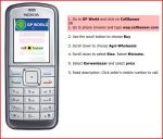
I have been particularly interested in the CellBazaar tutorials for the viewing of the available offers via mobile technology and for the submission of offers. The tutorials feature the procedures for announcing a sell lead and for checking the sell leads. The procedures (SMS Buy, SMS Sell) involve the sending of 4 text messages in order to sell, and of 5 messages in order to buy. In response, the user of the system receives lists of the available metacathegory, cathegory, sub-cathegory and price range options. The user makes a choice by texting to CellBazaar the number of the selected option.

wap-buywap-sellThe buying and selling procedures are less clumsy when the users have WAP trechnology at their disposal. The buying and the selling procedures are explained respectively at WAP Buy and WAP Sell.

Considering the SMS and WAP procedures one fact sticks out. In neither selling procedures (SMS or WAP) is the user required to specify his/her location. In the WAP Buy procedure once a buyer chooses the sub-cathegory of goods he/she is interested in, he/she needs to specify a location and a price range. In the SMS Buy procedure the is required to specify a price range. This all leaves the question open as to how CellBazaar is able to know the location of its users. Is anyone aware of what location technology they are using? If CellBazaar do indeed infer the location of their users without asking them to confirm it, that seems to me a rather poor practice. If it is otherwise, I would very much appreciate hearing about it.